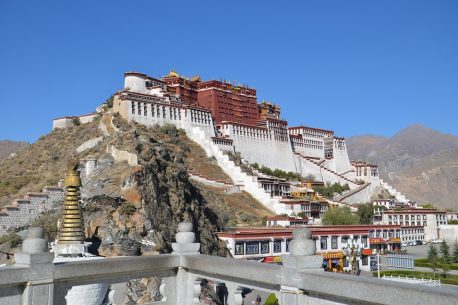
1. GRAND ITALIAN TRAIL Record for the beautiful country that excels in this ranking, despite Italy is not a country of “very large” geographical dimensions. From East to West, from North to South, Italy is a country that, thanks to its shape and above all to its morphology, lends itself perfectly to hiking: starting from the province of Sgonico, Trieste, and more precisely from the Grotta Gigante this long route that winds for about 6,166 kilometers across the country. From the far east, we proceed along the majestic alpine massifs towards the west, towards Genoa, and from here begins the descent inside the boot. Leaving the rugged alpine peaks, you skirt the gentler peaks of the Apennines which, starting from Liguria, cross and divide Italy on the two sides and, possible paths: following the Tyrrhenian coast you will first cross the Tuscan-Emilian Apennines and then, proceeding towards the south you will touch Lazio, the Abruzzese mountains and Molise. Continuing to “roll towards the South” you cross all the regions of the South: Campania, Puglia, and Calabria until you reach the Sicilian land. The route ends in Sardinia, in the north-western part of Santa Teresa di Gallura. A long route that until now corresponds to only part of the journey: the return, always passing through Sicily and climbing the boot heading towards the North-East. time, it will allow visiting in-depth the southern regions bordering the Adriatic coast. A journey through the 20 Italian regions, a journey through a reality that changes step by step, region after region in a peculiar and characteristic natural spectacle that is always different, unique macro-environments where the nature and culture of the place create different but always deep bonds, roots, and traditions that all refer to Made in Italy.
  2. CONTINENTAL DIVIDE TRAIL The Continental Divide Trail is the longest route in the Triple Crown of Hiking, completed by the Pacific Crest Trail and the Appalachian Trail. The 5,000-kilometer trail runs through the states of New Mexico, Colorado, Wyoming, Idaho, and Montana, covering the central part of the United States. Tradition has it that the arrival point is at Crazy Cook, near the village of Colombus in New Mexico but, due to the arid conditions and the scarcity of services, we advise you to leave from here heading north. Covering about 1000 kilometers between deserts and cacti, with barren landscapes as far as the eye can see, we proceed towards the San Juan Mountains, in the southern part of Colorado, and the Sawatch Mountains in the central part: the uninhabited “ghost towns” are of great impact. peculiar for the western charm they transmit, as the remains of ancient “living” cities built in the gold rush era. The portion of the path that crosses the state of Wyoming takes you to a site that is particularly important for American history: in addition to being the site of ancient battles between the British independence colonies and the American Indians, it passes through Yellowstone Park. One of the oldest and largest parks in the world; which in addition to hosting many animals and a variegated flora is renowned for its numerous Geysers. Old Faithful is one of the oldest and most famous geysers in the world. Before arriving in Montana, where this long and tiring journey ends, you will briefly cross the state of Idaho which is now one of the few natural areas in the United States.
  3. PACIFIC CREST TRAIL (EAST COAST) Also known as the National Scenic Trail, this is the second triple crown trail and branches off the Pacific coast of the United States. Spread over a length of 4,286 kilometers, it has its terminus respectively in Campo (California) close to the Mexican border, and at the gates of Manning Park in British Columbia (Canada) in the northern part. The track runs through the most isolated parts, showing unique natural spectacles of their kind but only to those who have the strength, mental and above all physical: in California, you can admire the magnificent King’s Canyon and the Sequoia National Park, close to the Sierra Nevada. they are home to the largest sequoias left in the world and, on the border between these two parks, stands the Forester Pass, the highest point of the track with an elevation gain of 4009 meters. Heading north you enter the state of Oregon with small steps, even here nature has not been stingy with shows: the Crater National Park is a protected area in which one of the most beautiful and deepest lakes in the world is located: born in following a volcanic sinking and fueled by the melting of the surrounding snow, this lake is so clear that it is a natural mirror in which the whole panorama merges into a marvelous spectacle. On the border with Washington state, we find the gigantic Columbia gorge, where the namesake river, winding westwards, has over time traced the only navigable route to the Pacific Ocean. A shortstop in the city of Cascade Locks, where the lowest point of the track is recorded, and proceed towards Manning Park where this crazy adventure will end: but first stop to admire the imposing massifs Mount Adams and Mount Rainier which are part of the chain of falls, Washington state.
  4. TE ARAROA TRAIL (NEW ZEALAND) New Zealand, located 200 kilometers south-east from Australia, is an island state in Oceania: it is an archipelago formed mainly by the islands of the North and South; presenting an environmental diversity that is best suited for hiking and trekking activities. The idea was to create a “single path” that crossed the entire New Zealand territory, such as to allow every type of tourist to be able to live this experience and this territory uniquely and intimately: completed in 2011, the Te Araroa Trail is not a simple trekking route, but it is an opportunity to experience a territory, learn about its traditions and its bond with nature. The route generally starts from the picturesque Cape Reinga lighthouse on the North Island, in the direction of the large South Island, but it is also possible to do the reverse: we recommend proceeding as usual due to the morphological diversity of the territory; being the North Island very flat it is advisable to accustom the body gradually. During the “descent” which will take you for about 5-6 months, you will pass through many of the New Zealand regions: Northland, Auckland, Waikato, Whanganui, Manawatu, and Wellington. Once you arrive in the capital you must take a ferry to continue the journey on the South Island, where you cross the regions of Nelson Marlborough, Canterbury, Otago, and Southland. As mentioned above, this island is much wilder and morphologically impervious, it requires a certain physical prowess to continue the trail: between the inaccessible and cold alpine peaks and the steep valleys, typical of the internal part, one arrives slowly towards the extreme south of the island, towards Bluff.
  5. APPALACHIAN TRAIL (WEST COAST) The chain of the Appalachian Mountains extends over the eastern part of the United States, from the Gulf of San Lorenzo to the state of Alabama for a length of almost 2500 kilometers: between these rugged mountains, the path of the same name winds starts in the south, from Mount Springer in the enchanting Chattahoochee-Oconee forest in a north-east direction towards Mount Katadhin. From Georgia to the state of Maine, passing through the endless spruce forests in Tennessee and North Carolina, in the direction of the state of New York. And again up, towards Massachusetts and New Hampshire to arrive after 3150 kilometers and crossing 14 states, on the slopes of Mount Katadhin. The path presents many critical issues due largely to the morphology of the terrain: the dense vegetation, the crevasses of the mountains and the 141,580 meters of altitude difference greatly affect the difficulty and duration of the route, which is estimated between 5 and 7 months. Last September, professional ultrarunner, Karl Meltzer finished the course in just over 45 days, setting a world record.
  6. HENRO NO MICH (WAY OF THE 88 TEMPLES – JAPAN) Japan, the island of Shikoku, is the smallest of the large islands that make up the Japanese archipelago: geographically far from the “hectic life” that characterizes Japan, it has always been a macro-environment to in its own right, in which the strong sense of spirituality and the link with ancient traditions have helped to preserve this spirit over time. From the city of Naruto, proceed clockwise towards the east for 1200 kilometers following the perimeter of the island and alternating views of the Pacific Ocean with those of the promontories, rice fields, and millenary villages; but the peculiarity of this journey in Japan are the 88 Buddhist temples scattered along the route, which make this experience not only a long journey but an opportunity to get in touch with this culture so tied to religious traditions. The trail is well signposted and is mostly located on asphalt, but there are more adventurous sections in the interior of the island. This path has a peculiarity: conventionally there is no starting and ending point, this is because the motivation that should push, Japanese and non-Japanese, is the possibility of “increasing one’s spiritual powers through this path”. A bit like Cicero said: “Per Aspera ad Astra”.
  7. TRANS PANAMA TRAIL (COSTA RICA – PANAMA – COLOMBIA) The history of this South American route is somewhat similar to the New Zealand route of the Te Araroa: strongly desired by Panamanian citizens to rediscover, especially to the new generation but not only, the beauty and the strong link between this territory and the culture of the place, but it was also decided to resume the ancient routes traveled in the past to appreciate the splendor of these places uniquely and differently. From Colombia to Costa Rica, passing precisely from Panama, this long trekking route winds for about 1200 kilometers in a variety of natural landscapes typical of South America: dense and immense rainforests, marshes and vast rivers to cross, hills to conquer, and peaks to climb. This and much more for lovers of adventure and nature who for about 4 months will leave the comfortable habits to immerse themselves in this experience.
  8. BAKER TRAIL (SOUTH SUDAN – UGANDA) The explorer and anthropologist Julian Monroe Fischer in collaboration with the Ministry of Tourism of Sudan and the Ministry of Tourism of Uganda, started a project in 2013 for the establishment of a natural path that connected South Sudan to Lake Albert in Western Uganda: retracing the ancient route crossed by the explorers’ Sir Samuel and Lady Florence Baker in the expeditions of 1860 – 1870 within the African continent. The purpose of the project, in addition to being a tribute to the two European explorers who first dared to enter the impervious black continent, is intended to be a strong impulse, for both countries, to overcome the bloody conflicts that have impoverished and destabilized these reasons for a very long time. The route runs for about 800 kilometers within the two states: starting from the capital of South Sudan, Gondokoro, it goes towards the central western border between Uganda and the Democratic Republic of Congo where Lake Albert is located, the final destination of the path; before getting lost in the spectacle of one of the largest African lakes, let yourself be carried away by the Karuma falls to the east of the lake and the Murchison Falls to the west, in the great nature reserve crossed by the imposing White Nile.
  9. CAMINO DE SANTIAGO DE COMPOSTELA (SPAIN) One of the most visited and famous routes in the world, traveled every year by 4,000,000 pilgrims, faithful and hiking lovers. It is a path that can be walked in many ways, whether you choose the most used route or you want to follow your own direction, it is well signposted and offers numerous hostels and refreshment points throughout the journey. The “Spanish” part of this long religious journey that actually begins in France, but can also be reached from Italy via the Via Francigena: it starts from the city of Navarra on the north-eastern border with France, and winds through the Spanish state for about 800 kilometers westwards, towards the Atlantic Ocean.
  10. GR20 (SENTIER DE GRANDE RANDONÉE) The GR20 is a hiking route in Corsica: about 180 kilometers long, it crosses the large French island obliquely: starting from Calenzana in the north-western part of the island, it continues towards south-east where its terminus, Conca, is located. The route can be divided into two portions: the GR20 North and the GR20 South which have as their intermediate terminus the city of Vizzanova, in the heart of Corsica. The route has a strong morphological dichotomy: the northern part requires a greater physical effort, as this portion has high mountains and very steep ridges which are difficult to climb; the second part is easily practicable, in fact being gentler and flatter it will require less physical effort and you will have time to enjoy this naturalistic spectacle. The itinerary, always well marked with special white and red symbols, can be covered in about a month, but don’t be fooled by the short duration, although it is the shortest in this ranking, it still implies a certain type of physical form.

More travels you be might be interested in
Trekking Tibet Kailash

Duration: 18 days / 16 nights

from € 5,093 - Flights excluded

Duration: 9 days / 8 nights

from € 2,260 - Voli esclusi

LightTrekking in Oman

Duration: 14 days / 13 nights

from € 2,331 - Flights excluded

Articles you might like
Grotte di Lascaux

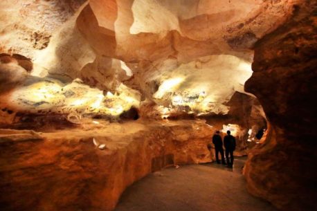
Lascaux caves Do you believe it is true that time passes inexorably? Obviously yes but not in Lascaux! In this place the passage of time seems to have crystallized: with its suggestive caves, which are located near the village of Montignac, in south-western France, we are catapulted into the Paleolithic! The particularity of the Lascaux […]

Trekking in Mongolia presso il Tavan Bogd

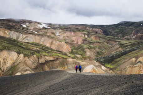
Trekking in Mongolia at Tavan Bogd Tavan Bogd is a mountain massif in Mongolia, located near the border with China and Russia. Its highest peak, the Hùjtnij Peak, formerly known as Nairmadal Peak, or the “Peak of Friendship”, is the highest point in Mongolia, is located at 4374 meters above sea level and has a […]

Our Tour Operators at your service for your travel experience without borders. Click and go.

Our clusters: realize the dream of a trip for your needs and passions. Click and go.

We make it easy to plan and arrange a business or work trip. Click and go.

Dedicated to travel agencies. Click and do business with Go World.

For social media lovers. Click and dream about your next trip.

Do not miss our offers!

Text for the consent of the treatment of personal data: By filling in and sending this form, you agree to the processing of personal data provided by you for the purposes and within the limits indicated in the site's privacy policy, pursuant to and for the purposes of Regulation (EU) 2016 / 679 (GDPR).

Go World S.r.l.
via Canale, 22 - 60125 Ancona
P.IVA, CF 02763050420 R.E.A. AN 213201
Capitale Sociale € 10.000
Premio Turismo responsabile Italiano 2011
ASTOI Fondo di Garanzia ASTOI